What is a MWEE and Time Sheet Prep Slides shown at GMU Orientation online (you do not need a passcode to download)
Zoom Recording of What is MWEE
Passcode: @z53?LgX
Spatially Connecting Kids to the Bay -
Meaningful Watershed Educational Experiences (MWEE) for FCPS 7th Grade Life Science students
Students will have completed water quality and ecosystem activities prior to this MWEE field experience. You will see those activities referred to (e.g. Beneath the Surface) in the two FCPS Testing the Waters guides posted below, which I combined into one doc. The Interpreter Station notes give you a play by play on how to lead stations 1-4.
- FCPS Testing the Waters Student Guide - FCPS Testing the Waters Teacher-Interpreter Guide
**2017 Interpreter Training Guide**
2012-2013 Interpreter Station Notes - with point scales for the FCPS MWEE
*Read how Stormwater is Managed in Fairfax County 2010*
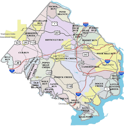
We provide MWEEs in the 3 watersheds below. Kids need to know where the watershed is located, condition of the watershed & the path water takes to the Bay.
 |
|
 |
| Accotink Creek Watershed - Accotink Creek |
Difficult Run Watershed - Lake Fairfax |
Pohick Creek Watershed - Burke Lake |
| Summary of Conditions | Summary of Conditions | Summary of Conditions |
| Streams in the Accotink Creek watershed are substantially degraded, with the majority of tributary systems exhibiting poor habitat and biological conditions. characterized by heavy development throughout most of the watershed > 25% impervious surface | Development intensity in the watershed ranges from 8.2 to 27.4% Colvin Run, which was dammed to form Lake Fairfax, drains areas levels of imperviousness over 20%. |
All drainages in watershed exhibited levels of imperviousness >20%, except South Run subwatershed (9 to 12% impervious cover). South Run was dammed for form Burke Lake. |
|
Accotink Lake Info Sedimentation Issue Friends of Accotink Park-great stewardship projects! Invertebrates found in Accotink Creek History |
Trout stocking dates
Fall 2011 Storm flow videos |
Because Burke Lake is intensively managed for the fishing resource, this lake is fertilized to increase algae growth. The zooplankton will feed on the phytoplankton(microscopic algae). Small fish and some invertebrates will feed on zooplankton; larger fish feed on smallerones . Thus the high phosphate fertilizer increases algae growth which reduces water clarity and makes the water a little greener in color.
|

Info on satellite sites: Meadowlark Gardens (Info) and Scott's Run (Info)
We will be teaching FOUR different stations at EACH stream or lake site. You will teach the same station each day, students & chaperons will rotate.
In addition to the "Testing the Waters' activity, Interpreters should be able to discuss/engage the kids with the information below to add great value to each station.
To further enhance your Chesapeake Bay knowledge, click on this Livebinder
Fairfax Counties Stream Protection Study - tells the history behind many of the constructed lakes in the county, effects of urbanization on streams and importance of biological monitoring. http://www.fairfaxcounty.gov/dpwes/publications/sps/spsch1.pdf
Park Information you should know to add value to your station
Lake Accotink map. Read through the history of the lake, why and when it was built.
Description
The headwaters of Accotink Creek are located in the center of Fairfax County and the stream drains southeast into Accotink Creek which flows into Accotink Bay which meets Gunston Cove which flows into the tidal Potomac River which flows into the Chesapeake Bay. Accotink creek's connection to the Bay.
Major Streams and Tributaries
Major tributaries to Accotink Creek include Bear Branch, Crook Branch, Daniels Run, Hunters Branch and Long Branch.
Watershed Size
51 square miles, total, 38 square miles within Fairfax County
Unique Features
Lake Accotink, with a surface area of approximately 70 acres, is located in the central portion of the watershed. Approximately 12 square miles of the watershed are not under the jurisdiction of Fairfax County, lying within the City of Fairfax or Fort Belvoir.
Why is Lake Accotink shrinking? Sedimentation! Learn more about sedimentation in Lake Accotink.
They have a HUGE problem with trash flowing into the lake every day. Loads and loads of trash are removed weekly, but the flow from the neighborhoods is endless.
Report card for Accotink Watershed.
Description
South Run was dammed to fill in this 218 acre lake that opened in 1963 and was constructed as a public fishing lake with monies derived from fishing licenses and federal monies. As you can see on the map, the dam is located at the south end of the lake. Water which spills over the dam, flows into South Run, which can can follow all the way to Lake Mercer. Lake Mercer is impounded by Pohick Creek Dam #1 Dam on the South Run River in Fairfax County, Virginia and is used for flood control and recreation purposes. The watershed for Lake Mercer is 6.2 miles2. From Lake Mercer the water continues to flow into South Run which eventually flows into Pohick Creek which flows into Pohick Bay and onto Gunston Cove and then onto the Potomac River which flows into the Chesapeake Bay.
Watershed Size
The Pohick Creek Watershed, is 36.5 square miles, most of which is in Fairfax County. Compared to much of Fairfax County and other areas within the Pohick Creek Watershed, Burke Lake has very high quality water, primarily due to the lower development pressure (fewer homes, businesses and roads) in the immediate area around the lake.
If you click on this map, and click satellite in the right corner, you can view the exact area where we will be teaching the students. Zoom in and then zoom out, and track the water flow all the way to the Bay.
Are nutrients like fertilizer 'bad' for the lake and the Bay? Yes and in Burke Lake--sometimes no. The folks from the VA Dept of game and Inland Fisheries feel that the fertilizer added to Burke Lake is immediately uptaken by the microscopic algae(phytoplankton) and as it moves up the food chain it promotes a healthy fishing industry. A corn-based agricultural fertilizer with a Nitrogen-Phosphate-Potassium ratio of 10-34-0, is applied at a rate of 1 gallon/surface acre of water at a frequency of about once per month from May-September. They know when it is time to reapply, because the water clears up and the secchi disk depth is 18” or greater.
In the Chesapeake Bay nutrients, like fertilizer and animal manure, are a BIG problem.
Why fertilize lakes and ponds? To increase the number of fish.
As the water temperature increases this spring into summer, students should see an increase in conductivity .
Lake Fairfax Dam is on the Colvin Run River in Fairfax County, Virginia and is used for recreation purposes. Construction was completed in 1956. It has a normal surface area of 21 acres. It is owned by Fairfax County Park Authority. Lake Fairfax Dam is of earthen construction. Though originally completed in 1956, the structure was modified in 1982. Its height is 32 feet with a length of 500 feet. Its capacity is 487 acre feet. Normal storage is 182 acre feet. It drains an area of 4.3 square miles.
Bay Daily Blog: gives you some Bay-related topic to share with the students if time permits.
Thanks so much to Fairfax County Stormwater Planning for lending us their expertise!